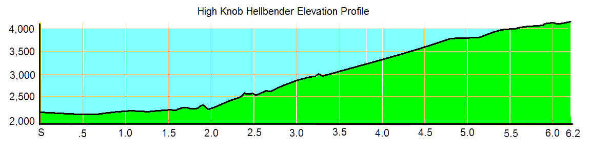
The High Knob Hellbender is an approximately 6.2-mile race that climbs more than 2,000 feet in elevation from its starting point in Norton, Va., the smallest incorporated city in the entire state, to the High Knob Observation Tower in the Jefferson National Forest.
See below route directions and this Strava Course Map for more details.
- The elevation is 2,200 feet above sea level at the starting point behind the city’s municipal parking lot.
- Head northeast behind downtown to Coeburn Avenue. Turn right and continue to the Kentucky Avenue intersection. The route turns right onto Kentucky Avenue, and a few early climbs might seem like the ascent has begun, but the best is yet to come!
- Pass beneath U.S. 23. Following a stout climb past the park, local landmark Benge’s Rock will be on the right. This is the first aid station.
- Farther up the road, runners pass by the entrance of Flag Rock Recreation Area, a city park named for an impressive overlook of Norton and the Virginia-Kentucky state line.
- Following a few more twists and turns, runners reach the city reservoir. This is the second aid station. This is also the main trailhead for the City of Norton’s Flag Rock Area Trails system, which is open to foot travel and mountain biking.
- The climbing only continues until runners reach the turn for U.S. Forest Service Road No. 238. After turning left, it’s only half a mile until the final push to the parking lot and 4,200-foot summit where an observation tower offers a 360-degree view of distant peaks as far away as the Great Smoky Mountains National Park and West Virginia. This is also the highest point in the Cumberland Mountains.
- Total elevation gain: 2,046 feet.

Leave a comment